
Visiones del Caribe Curricula
By Medardo Gabriel Rosario, Ph.D. and Alexander S. Butler, Ph.D.
Florida International University, Bowling Green State University
Introduction
The “Visions of the Caribbean” curriculum, tailored for higher education teacher candidates, aims to explore the multifaceted dimensions of the Caribbean region through literary and cartographic materials. This curriculum models for teacher candidates how to construct evidence-based responses to inquiries that lead their learners to understand the Caribbean’s history, literature, and geography. As noted by Shulman (1987), a teacher’s deep content knowledge significantly influences their instructional effectiveness. Therefore, this curriculum’s primary goal is to provide exemplary educational resources to teacher candidates, enhancing their content knowledge while developing critical thinking, analytical skills, and reflective practices through engagement with the Caribbean as a complex geographical and cultural entity, shaped by its resident and diasporic communities.
The central inquiry driving the three lessons is “What is the Caribbean?” This question is designed to prompt an extensive exploration of the region. By grappling with this question, teacher candidates will learn how to foster an appreciation for the Caribbean not merely as a geographic location but as a dynamic region teeming with diverse cultures, histories, and narratives. Through the examination of literary texts and cartographic sources, teacher candidates will uncover how the Caribbean has been influenced by various factors, from indigenous populations to colonial powers, and how these influences continue to shape its contemporary landscape. This question serves as a catalyst for teacher candidates to critically analyze the intersections of geography, culture, and history, and to grasp how the Caribbean’s distinctive identity is constructed and understood.
The first lesson, titled “Exploring Caribbean Boundaries,” challenges different definitions of the Caribbean region. Teacher candidates will investigate diverse perspectives on the geographical, political, and cultural boundaries of the Caribbean, analyzing how these definitions have evolved over time and the factors influencing these changes. This lesson encourages teacher candidates to contemplate the fluid and multifaceted nature of the Caribbean, shaped by historical events, migration patterns, and cultural exchanges.
The second lesson, titled “Encountering the Caribbean,” delves into the initial European encounters with the region and their interactions with indigenous communities. Teacher candidates will explore the early encounters between European explorers and native populations, examining the profound impact of these interactions on both groups. Through primary sources and historical accounts, teacher candidates will gain insights into the transformative effects of colonization, cultural exchanges, and the resistance of indigenous communities in the Caribbean.
The third lesson, titled “Afro-Caribbean Cultures,” investigates the presence and contributions of Afro-descendant communities in the Caribbean region, prompting a broader consideration of the Caribbean beyond its geographic confines. This lesson focuses on the rich cultural heritage of Afro-Caribbean communities, encompassing their traditions, music, religion, and social structures.
The curriculum aims to move beyond superficial comprehension, nurturing a profound understanding of the Caribbean’s global significance and its importance to its inhabitants. The lessons are structured according to the C3 Framework for Social Studies Standards, ensuring alignment with best practices in social studies education. Additionally, all primary sources (maps, engravings, texts, etc.) are sourced from the Digital Library of the Caribbean (dLOC) collections, and partners, providing participants with access to an extensive repository of authentic materials. We are not only using dLOC archives, but are connecting dLOC to other collections where students and educators can further their learning.
This resource is made and published by the creator under a Creative Commons Attribution NonCommercial 4.0 International License (CC-BY-NC 4.0). To view a copy of this license, visit https://creativecommons.org/licenses/by-nc/4.0/. This license enables reusers to distribute, remix, adapt, and build upon the material in any medium or format for noncommercial purposes only, and only so long as attribution is given to the creator

Work for this OER was supported in part by the Digital Library of the Caribbean through the Open Educational Resources in Caribbean Studies Project of the Revitalizing the Digital Library of the Caribbean initiative. Funding was generously provided by the Andrew W. Mellon Foundation.
The content of this OER is also available on StoryMaps platforms hosted by the authors: lesson 1, lesson 2, lesson 3.
Lesson 1: Caribbean Boundaries
Context
This lesson examines various definitions of what constitutes the Caribbean. Teacher candidates will explore different perspectives on the geographical, political, and cultural boundaries of the Caribbean, analyzing how these definitions have evolved and the factors that have influenced these changes. This lesson encourages teacher candidates to consider the Caribbean as a fluid and multifaceted concept, shaped by historical events, migration patterns, and cultural exchanges.
Question
What different ways can we define the Caribbean?
Objectives
- Identify and analyze various geographical, political, and cultural definitions of the Caribbean, understanding how these perspectives contribute to a broader concept of the region.
- Trace the evolution of the Caribbean’s boundaries, recognizing the impact of historical events, migration patterns, and cultural exchanges on these changes.
- Explain why the concept of the Caribbean is fluid and multifaceted, demonstrating an understanding of the region as a dynamic space shaped by diverse influences and historical contexts.
- Decide on what they believe the boundaries of the Caribbean are and reflect on the reasoning behind their decisions, considering various geographical, political, and cultural perspectives.
- Compare and contrast their perceptions of the Caribbean’s boundaries from the beginning of the lesson to the end, analyzing how their understanding has evolved based on historical events, migration patterns, and cultural exchanges discussed during the lesson.
Sources
- Map of the Antilles
- Map of the Caribbean Basin
- Map of the Cultural Caribbean
- Gaztambide, A. (2006). La invención del Caribe a partir de 1989. Jangwa Pana, 5(1), 1–23. https://doi.org/10.21676/16574923.441
Pedagogical Approach
Hook: Drawing the Boundaries of the Caribbean (10 minutes)
Purpose – This activity aims to set the stage for the Curricula’s Compelling Question and the lesson’s Supporting Question, “What different ways can we define the Caribbean?” while establishing a baseline for participants’ conceptions of the region.
Teacher Moves –
- Distribute or instruct participants to pull out paper and drawing materials (e.g., colored pens, pencils, markers, etc.).
- Ask participants to color on the provided map what they think is included in the Caribbean. The map can be found in the resource section at the bottom of Lesson 1.
- Give participants five minutes to color and then five minutes to discuss. Ensure participants save their colorings for later use at the end of class.
Explore: Primary Source Analysis: Observe, Reflect, Question Protocol (ORQ) (30 minutes)
Purpose – Participants identify and note details about different maps of the Caribbean. With each new source, participants are prompted to engage in the initial two steps of the Library of Congress’ Primary Source Analysis tool for Photographs and Prints, facilitating a comprehensive exploration of the maps. Through this activity, participants gain an understanding of several perceptions of the Caribbean. These include three of Antonio Gaztambide-Géigel’s (2006) four definitions of the Caribbean:
- El Caribe insular. It tends to be synonymous with the Antilles and the West Indies, often including the Guianas and Belize, and can extend to the Bahamas and Bermuda.
- El Gran Caribe. It adds Venezuela and parts of Colombia and Mexico.
- El Caribe Cultural (o Afro-America Central). It is not “geographical” in the sense of corresponding to political borders, but rather can include—due to its characteristics—parts of countries. It can be considered as the parts of Plantation America (or Afro-America) that lie between the United States to the north and Brazil to the south.
Once they have looked at the different maps of the Caribbean, they will complete the sentence-stems to present their conclusion about what they think the boundaries of the Caribbean are. While this might seem pedantic for post-secondary participants, this gives them the experience of completing the task in a way their future students will build the skills to draw conclusions and support their conclusions with evidence.
Professor Moves –
- Serving as the facilitator for the ORQ process, the Professor moderates discussions and guides participants through the analysis. A variety of Library of Congress analysis tools are available on this website, with the Photographs and Prints graphic organizer and prompts or the Analyzing Primary Sources graphic organizer and prompts being commonly used. Inference Squares and the Star Protocol (see example in the Resources section of this lesson) are also an option. It is recommended to either construct the graphic organizer on a white/chalk board or provide printed copies for individual or group use. Document on the board or have participants document their observations, reflections, and questions to establish connections between maps throughout the lesson. As the lesson progresses, participants will find answers to some of their questions, which should be recorded, akin to utilizing a KWL Chart. If there are participant questions that were not answered, these can be set aside to use as an extended learning opportunity. Not every question will help them achieve the lesson’s objectives, so make sure to use the ones that will challenge and engage participants to build their learning.
- Lead participants through the process of Observing the maps. Start with the map of the Caribe Insular. You can do this as a whole group or have participants pair up. The Professor can give prompts or ask questions like
- What do you see?
- What do you notice first?
- What places are shown?
- What is labeled?
- Introduce participants to the following resources and have them follow the Observation process above and the Reflecting and Questioning process below.
Explain: Completing the ORQ process. (20 minutes)
Purpose – Participants make inferences using the maps to define the Caribbean based on the map.
Professor Moves –
- Guide participants through the Reflection phase of the ORQ process, transitioning from mere observations to making inferences. Encourage participants to actively create and assess hypotheses related to the image.
- If there are symbols or colors, what do they stand for?
- Which places are emphasized or included?
- What places do you think are missing?
- How might this map shape perceptions about the Caribbean?
- Write one sentence describing the map.
- What would you entitle this map if you were trying to define the boundaries of the Caribbean?
- Have participants ask Questions to lead to more observations and reflections.
- What do you wonder about …?
- Record or have participants record their questions.
- You can try to answer some of these as a group, but remember that not every question will help them achieve the lesson’s objectives, so make sure to only discuss questions that will challenge and engage participants to build their learning about the maps.
Elaborate: Comparing the maps (20 minutes)
Purpose – Participants are given an opportunity to compare the maps side-by-side. The goal is to help participants see three of Gaztambide-Geígel’s definitions of the Caribbean and ask them to compare and contrast the maps.
Professor Moves –
- Put maps side-by-side on a screen or at their tables.
- Ask participants to record the similarities and differences between the places found on the map. Remember, the participants should be focusing on the places included on the map, not the characteristics of the map itself.
- Have participants share out their observations
- Using these observations, have participants discuss what the boundaries of the Caribbean should be.
- After participants engage with each of the maps, ask them to reflect on which of the maps representing Gaztambide-Géigel’s conceptions of the Caribbean their map (the one they created at the beginning of the lesson) is most similar to.
- Have them reference specific maps from the activities above in their comparisons.
Evaluate: Post-Drawing (15 minutes)
Purpose – Changes in participants’ conceptions of the Caribbean’s boundaries are measured. Participants color/draw a new response to the question “What are the boundaries of the Caribbean?”
Professor Moves – Redraw and discuss
- Have participants pull out another sheet of paper or pass out another map and have participants spend five-minutes coloring a new response to the initial question, “What are the boundaries of the Caribbean?”
- Have participants discuss their drawings as a whole class and then complete the Writing Frame in the Resources section.
- Observe if participants’ conceptions are more nuanced and reflect a larger version of the Caribbean.
Resources

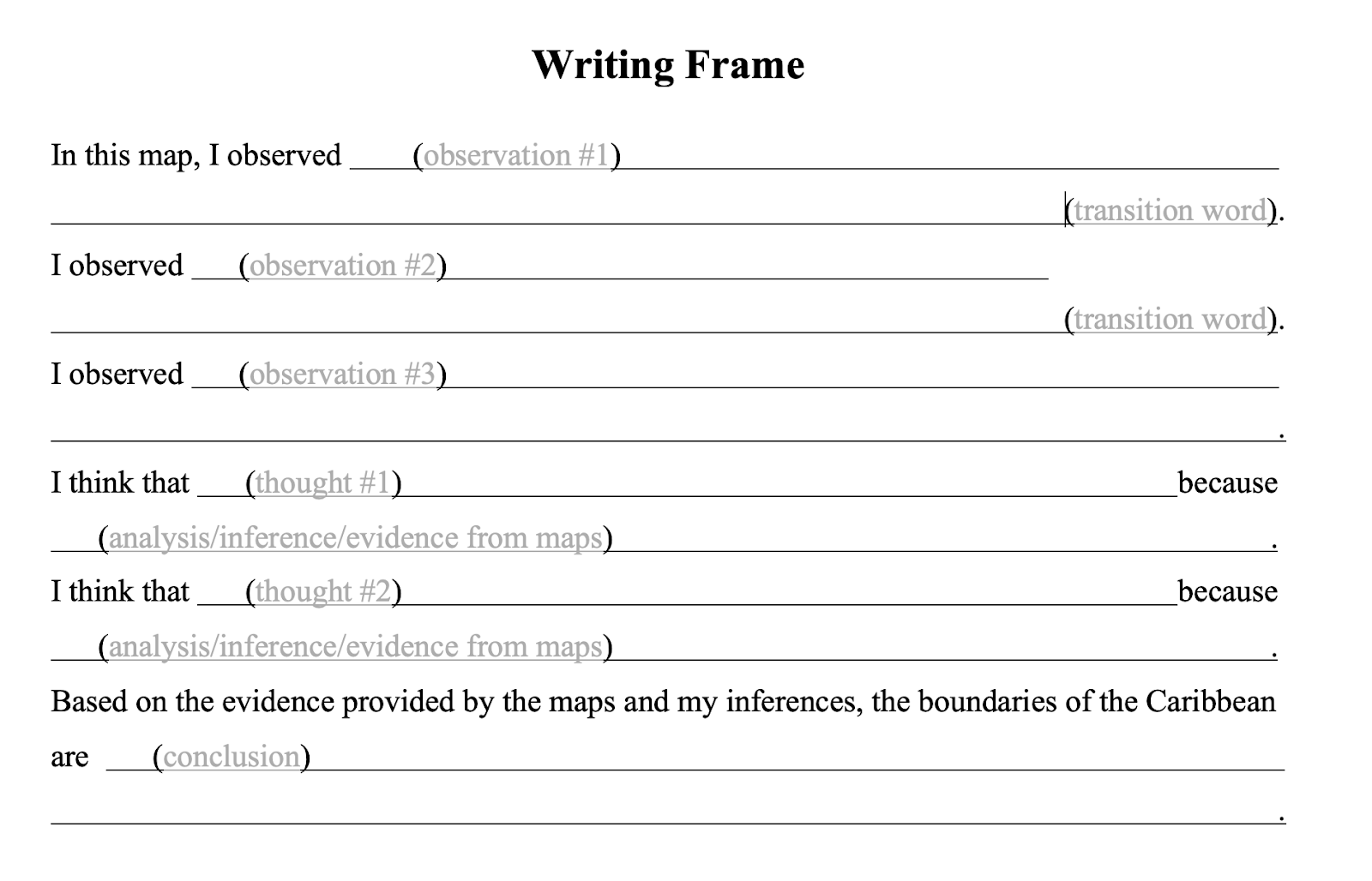
Template inspired by C3 Teachers Inquiry Design Model and the 5E Model.
Lesson 2: Caribbean Encounters
Context
The second lesson examines the arrival of Europeans in the Caribbean and their interactions with indigenous communities. Students will investigate the initial encounters between European explorers and native populations, analyzing the impacts on both groups. Using primary sources and historical accounts, they will explore the significant changes these encounters brought to the Caribbean, including colonization, cultural exchanges, and indigenous resistance.
Question
What was the Caribbean like during the initial contact with Europeans? (Insular Caribbean)
Objectives
- Compare and contrast your initial perception of the Caribbean with 16th-century representations of the region.
- Explain the motives of those arriving in the Caribbean using supporting evidence.
- Compare and contrast Columbus’ perspectives of the indigenous people with those of the Taíno.
- Construct a response to the guiding question of the lesson and reflect on why your perspective remained the same or changed, using evidence from the sources.
Sources
- Alain Manesson Mallet’s rendering of the Lucayan Archipelago
- Excerpt from Columbus’ Diary
- Theodore de Bry’s engraving
- Posthumous portrait of Columbus by Sebastiano del Piombo
- An Account of the Antiquities of the Indians, by Ramón Pané
- Sandra Zaiter’s video about the Taino
- Cemí image
Pedagogical Approach
Hook: Drawing the Caribbean (5 minutes)
Purpose – This activity aims to set the stage for the workshop’s overarching question , “What is the Caribbean?” while establishing a baseline for participants’ conceptions of the encounter between Europeans and the Taino.
Professor Moves –
- Distribute or instruct participants to pull out paper and drawing materials (e.g., colored pens, pencils, markers, etc.).
- Ask participants to draw or write their response to the question: “What do you think Christopher Columbus saw when he arrived in the Caribbean?” Tell them to be as detailed as possible.
- Give participants five minutes to draw/write and then five minutes to discuss. Ensure participants save their creation for later use at the end of the lesson.
Explore: Primary Source Analysis: Observer, Reflect, Question Protocol (ORQ) (30 minutes)
Purpose – Participants identify and note details about different sources from the European perspective of the Encounter. With each new source, participants are prompted to engage in the initial two steps of the Library of Congress’ Primary Source Analysis tool for Photographs and Prints, facilitating a comprehensive exploration of the sources. Through this activity, participants build several key skills, such as analyzing sources. Participants also build important content knowledge by learning about European representations of the Caribbean and its people.
Professor Moves –
- Serving as the facilitator for the ORQ process, the professor moderates discussions and guides participants through the analysis. A variety of Library of Congress analysis tools are available on this website, with the Photographs and Prints graphic organizer and prompts or the Analyzing Primary Sources graphic organizer and prompts being commonly used. Inference Squares are also an option. It is recommended to either construct the graphic organizer on the board or provide printed copies for individual or group use.
- Document participants’ observations, reflections, and questions to establish connections between sources throughout the lesson. As the lesson progresses, participants will find answers to some of their questions, which should be recorded, akin to utilizing a KWL Chart. If there are participant questions that were not answered, these can be set aside to use as an extended learning opportunity. Not every question will help them achieve the lesson’s objectives, so make sure to use the ones that will challenge and engage participants to build their learning.
- Initiate this activity by examining sources portraying the European perspective. They begin with a map illustrating Columbus’ voyage, followed by his diary entry describing the encounter with the Taino, and finally, an engraving depicting the first encounter. The professor instructs participants to utilize Columbus’ and other European representations as evidence in addressing the following question:
- What was the European perspective of the Americas at their first landing?
- Lead participants through the process of Observing the sources. For pictures, the professor can give prompts or ask questions like
- What do you see?
- What do you notice first?
- What people and objects are shown?
- How are they arranged?
- What is the physical setting?
- What, if any, words do you see?
- What other details can you see?
E.g., When we ask them to observe what they see in Mallet’s cartographic representation of Lucayan Archipelago, we ask participants to consider the perspective of the image, the proportion of the items in the island in relation to each other. For de Bry’s engraving, we make sure to compare the Europeans with the Taino.
Introduce participants to the following resources and have them follow the Observation process above and the Reflecting and Questioning process below.
- Alain Manesson Mallet’s rendering of the Lucayan Archipielago (1685);
- Excerpt from Columbus’ (1530s/1989) diary1 narrating his first encounter with the Taino people;
- Theodore de Bry’s engraving of Columbus arriving in America (1594); and
- Posthumous portrait of Columbus by Sebastiano del Piombo (1519).
Explain: Completing the ORQ process. (20 minutes)
Purpose – Participants make inferences using evidence from the sources to express what they learned through the European sources.
Professor Moves –
- Guide participants through the Reflection phase of the ORQ process, transitioning from mere observations to making inferences. Encourage participants to actively create and assess hypotheses related to the image.
- Why do you think this image was made?
- What’s happening in the image?
- When do you think it was made?
- Who do you think was the audience for this image?
- What was the intended narrative of the map or image?.
- What tools were used to create this?
- What can you learn from examining this image?
- What’s missing from this image?
- If someone made this from the Taino perspective, what would be different, the same?
- Have participants ask Questions to lead to more observations and reflections.
- What do you wonder about …who? · what? · when? · where? · why? · how?
Elaborate: Building new perspectives of the Encounter (20 minutes)
Purpose – participants are introduced to the Taino culture. Since we do not have recordings of Taino thoughts about the encounter, participants are asked to use their historical imagination based on what they learn about the Taino to compare to the European perspective. Additionally,participants listen to an adapted reading of the Taino Creation Story. This story was recorded by Fray Ramón Pané. Though recorded by a European, it gives us insight into Taino culture. The goal is to help participants recognize the complexity of the Taino people beyond the portrayal given by Columbus in his diary.
Professor Moves – Read participants an adapted version of the Taino creation myth from Pane’s work. Use a visual and multimedia source to further build participants’ knowledge of the Taino people.
- Participants listen to the professor read the Taino origin story from Pane’s work
- As the story is being read, have participants draw the story. After they draw it, give participants an opportunity to discuss how this story connects with what Columbus said about the Taino in his diary.
- Show a cemí for participants to compare with the story and their drawing. A cemí is a religious symbol that partially represents the Taino Creation Story through its shape.
- Show the music video of “Canción de los Taínos” by Sandra Zaiter. The music video demonstrates a Taino village and the types of things villagers did. You can have participants record their observations of the everyday tasks the Taino completed and how they interacted with one another. Using these observations, have participants compare their everyday activities to the Taino.
- Questions can be asked like:
- What were the Taino doing?
- Do you do any of the same types of things?
- After participants engage with each of the sources, ask them to reflect on whether Columbus’ description of the Taino captured the culture of the Taino.
- Have them reference specific sources to explain their conclusions.
Evaluate: Post-Drawing (10 minutes)
Purpose – Changes in participants’ conceptions of the Caribbean are measured. participants draw a new response to the question “What was the Caribbean like during the initial contact with Europeans? What is the Caribbean?”
Teacher Moves – Redraw and discuss
Observe if participants’ conceptions are more nuanced and reflect the Caribbean, not just as a space, but a space with a complex culture already present.humans in it.
- Have participants pull out another sheet of paper and spend five-minutes redrawing or rewriting a response to the initial question, “What was the Caribbean like during the initial contact with Europeans?What is the Caribbean?” In our experience, participants add people, buildings, and a more balanced depiction of the space. It transforms from merely a tourist destination to a portrayal that includes the Taino and/or others with whom participants share closer connection.
- Have participants discuss their drawings as a whole class.
- Observe if participants’ conceptions are more nuanced and reflect the Caribbean, not just as a space, but a space with a complex culture already present.humans in it.
Lesson 3: Caribbean Afro-Cultures
Context
The third lesson delves into how the existence of African descendant communities in the region opens avenues for reimagining the Caribbean beyond its geographical boundaries. This lesson highlights the vibrant cultural legacies of Afro-Caribbean communities, encompassing their traditions, music, religion, and social organization.
Question
What cultural elements connect different parts of the Caribbean?
(Caribe Cultural or Afro-Central American Caribe)
Objectives
- Compare and contrast sources on enslavement and stories of resistance across various Caribbean regions.
- Examine differences and similarities in food, music, and cultural expressions within Caribbean contexts.
- Construct an argument elucidating the complexities inherent in defining the Caribbean.
- Propose a redefined concept of “What is the Caribbean?” using all three lessons and reflecting on how this perspective has evolved or remained consistent, supported by evidence from the sources.
Sources
- Clark, William (1823). Ten views in the island of Antigua.
- Burnette, M. (1978). Pan and Caribbean drum rhythms. Jamaica Journal. March. 14-20.
- Hernádez, A. M. (2012). Que rico mambo. @hora. 342. p. 3.
- Elder, J. D. (1962). Calypso. 9-12. History and development of carnival, calypso, steelband.
- Maddox, C. (2015). Drum, dance, and the defense of cultural citizenship: Bele’s rebirth in contemporary Martinique. [Dissertation, University of Florida]. Digital Library of the Caribbean.
Pedagogical Approach
Hook: Word Cloud (5 minutes) or Exercise on Agency
Purpose – There are two options for activities as the hook. The first option introduces the Supporting Question, “What cultural elements connect different parts of the Caribbean?” by prompting critical reflection on the terms “slave” and “enslaved,” encouraging participants to explore the implications of language in historical and cultural contexts. The second option introduces the Supporting Question, “What cultural elements connect different parts of the Caribbean?” by having students look up how the Afro-identities in the Caribbean inspired freedom in different routes.
Option One Teacher Moves –
- Write the terms “slave” and “enslaved” on the board.
- Ask participants to pair up and discuss the definitions and implications of “slave” and “enslaved” for one minute.
- Invite pairs to share their insights, one word at a time.
- Document their ideas on the board around the terms “slave” and “enslaved” to collectively construct a nuanced definition for each.
- Facilitate a discussion highlighting the differences between the terms, emphasizing that “slave” objectifies the individual, whereas “enslaved” recognizes the condition imposed on a person.
Option Two Teacher Moves
- Split students into three groups and pass out a list of names to each group.
- Group 1: Archibald Monteith, Queen Nanny, The Igbo of Ebo Landing, Anténor Firmin
- Group 2: Jose Antonio Aponte, Chica da Silva, Escrava Anastacia, Arturo Schomburg
- Group 3: Benkos Bioho, Gaspar Yanga, Sarah or Sally Bassett, Bayano
- Have students use their devices to research the time period the person operated, where they came from, and what they hoped to achieve and through what means. They can also answer questions like:
- What present day countries was this person involved in?
- What period of colonization did they live?
- Why is this person important?
- What type of resistance, passive or active?
- How did their African roots shape their form of resistance?
- End by helping students discuss how these people always had an understanding of liberty rooted in their Afro-identities.
Explore: Primary Source Analysis – Observer, Reflect, Question Protocol (ORQ) (30 minutes)
Purpose – To engage participants in the analysis of primary sources depicting plantation culture, employing the Library of Congress’ Primary Source Analysis tool for a comprehensive examination. This activity aims to develop participants’ skills in source analysis and understanding shared Caribbean experiences.
Teacher Moves –
- Introduce participants to Ten views in the island of Antigua (1823) by William Clark.
- Guide participants through the observation process with advanced prompts such as:
- What specific elements of the scene stand out to you?
- How do these elements reflect broader socio-economic and cultural contexts?
- What are the power dynamics depicted in the sources?
- How does spatial arrangement convey relationships and hierarchies?
- Facilitate the ORQ process, encouraging deeper analysis and discussion. Utilize advanced Library of Congress tools tailored for higher education.
- Document observations, reflections, and questions, creating a repository of insights that will be referenced throughout the lesson.
- Encourage participants to critically assess and interconnect findings from different sources.
Explain: Completing the ORQ Process (20 minutes)
Purpose – To guide participants in making inferences using evidence from the sources, identifying thematic similarities in representations of enslavement, and drawing connections to broader historical and cultural narratives.
Teacher Moves –
- Lead participants through the Reflection phase of the ORQ process, emphasizing critical thinking and hypothesis formulation.
- Facilitate in-depth discussions with questions like:
- What motivations might have driven the creation of these images?
- What socio-political contexts are reflected in these representations?
- How do power relations manifest in these depictions?
- What intended narratives and audiences can be inferred from these sources?
- Encourage participants to draw parallels and contrasts between different images, fostering a comprehensive understanding of the material.
- Having analyzed and discussed the primary sources, we now move on to explore the broader cultural connections within the Caribbean. This next section will build on your observations and reflections, allowing us to examine the interconnectedness of the Caribbean through shared cultural elements.
Elaborate: Building Interconnectedness Across the Caribbean through Afro-Diasporic Cultures (20 minutes)
Purpose – To explore the cultural interconnectedness of the Caribbean through the examination of shared elements in music, fostering an appreciation of Afro-diasporic influences across the region.
Teacher Moves –
- Set up three stations, each featuring one article about a type of music. Have students read the excerpts or articles, analyze any images and then engage in the prompts in Step 2.
- Station 1: Read and analyze images in Burnette, M. (1978). Pan and Caribbean drum rhythms. Jamaica Journal. March. 14-20.
- Station 2: Read Hernádez, A. M. (2012). Que rico mambo. @hora. 342. p. 3.
- Station 3: Read Elder, J. D. (1962). Calypso. 9-12. History and development of carnival, calypso, steelband.
- Station 4: Read pages 36-39 of Maddox, C. (2015). Drum, dance, and the defense of cultural citizenship: Bele’s rebirth in contemporary Martinique. [Dissertation, University of Florida]. Digital Library of the Caribbean.
- Encourage participants to engage in discussions at each station with advanced questions such as:
- What is this music?
- What are some characteristics of the genre?
- Think about instruments and rhythms.
- Where is your music from in the Caribbean?
- What are the roots of this music?
- How do these cultural elements reflect historical processes of migration and exchange?
- In what ways do these elements represent syncretism and hybridity in Caribbean culture?
- How have these cultural practices evolved over time and across different regions/islands?
- Have participants document their insights and present their findings to the class, referencing specific evidence from the sources and drawing broader cultural connections.
Evaluate: Post-Discussion Drawing (10 minutes)
Purpose – To assess participants’ evolving understanding of the Caribbean by having them create a presentation that synthesizes their learning and articulates their revised conceptions.
Teacher Moves –
- Pair participants and instruct them to create a presentation using sources from all lessons, as well as additional research. The presentation should demonstrate their understanding of the Caribbean, highlighting how their perspectives have evolved.
- Encourage the use of multimedia elements and critical analysis to support their conclusions.
Footnotes
1 Fragment of the Diario del primer viaje de Colón (1492/1995) 12 de octubre de 1492 […]Y todos los que yo vi eran jóvenes, ninguno tenía más de treinta años. Eran bien proporcionados, de muy hermosos cuerpos y muy buenas caras. Tenían los cabellos gruesos como las colas de caballos y corto. Los cabellos los traen por encima de las cejas, excepto en la parte de atrás que los llevan largos, porque nunca se los cortaban. Su piel no era blanca ni negra y la pintaban de negro, blanco y rojo. No traían armas ni las conocen […] (p. 398).
